
Welcome back to Diaries from Analog Mars. If this is your first visit, consider reading the previous entries here. In part seven Jin and his team begin their research and encounter their first significant problems while on EVA.
Diaries From Analog Mars Menu
“Mars is a harsher place than any on Earth. But provided one can survive the regimen, it is the toughest schools that are the best.”
Dr robert zubrin, the case for mars (1996)
Mars was ramping up the difficulty. It was about to test us both mentally and physically, and valuable lessons were about to be learned.
A couple of days before, we had gotten a supply drop from Dr. Rupert to restock our food supplies, which included a goodie that I had been eagerly awaiting: peanut butter! On Sol 4, after Dave made delicious breakfast pancakes that were famous across an astounding 100% of the (human) population of Mars, I applied generous amounts of peanut butter to mine. I would need the calories for Lindsay and mine’s EVA later that day.
Lindsay is a JSPS postdoctoral fellow at the University of Tsukuba in Japan, where she conducts biological and bioinformatics research on space datasets. That’s about all I understand of her job. However, she did bring a fascinating project to the MDRS that she would work on during our EVA, which could one day help find life on another world.
Since I would be joining her on EVAs to record geographical data, I decided to learn more about her work. I had no background in biology beyond taking a course on it in Grade 11, but Lindsay did an excellent job of explaining her work to me.
Traditionally, there are a few ways to identify the kinds of microorganisms in a sample.
Most commonly, one could conduct a targeted analysis by culturing the sample in a Petri dish. If a scientist has a good educated guess of what microbes are present in the dish, they could add food to it that they know those microbes like the best. If colonies of those prospective microbes grow and show up on the Petri dish, then the scientist knows that their guess was right. This method does have some major problems: it requires some a priori knowledge of what kinds of microbes are present in the sample, and it can be difficult to identify newly discovered microbes because the culturing method does not sequence their DNA.
So, the scientist may instead choose to sequence the DNA of microbes in the sample, also known as using ‘genomic’ or ‘metagenomic’ methods. One of these methods may be very familiar to those of us who have had to travel recently: polymerase chain reaction, also known as PCR. The scientist could obtain the DNA sequences of the microbes and obtain well over 99.99% accuracy. However, they would need to have a substantial lab available to them. This may not be practical to bring on an early expedition to another world.
Lindsay aimed to test a relatively new method at the MDRS: a handheld genetic sequencer called a MinION. It is a grey, oblong device approximately the size of a TV remote that plugs into a laptop, like an oversized flash drive. This small instrument could be easily brought onto a crewed expedition to Mars and be used to identify alien life there, if it uses DNA.
In 2020, a team of researchers from McGill University, the University of Winnipeg, and the Centro de Astrobiología (INTA-CSIC) travelled to the Jotunheim structure, an inverted river channel about 1.3 kilometres north-north-east of the MDRS Hab (see footnotes for bibliography.) A long time ago, water flowed in this now-desert, depositing sediments onto the riverbed. As water penetrated the sediments, it formed areas that became cemented together. Over time, the surrounding material eroded away, leaving behind the cemented part – this became Jotunheim.

The research team targeted the red, iron oxide-rich regolith on Jotunheim’s slopes and took samples from them. Then, they transported them back to Montreal under refrigeration, where a MinION instrument successfully characterized the DNA in the samples.
Lindsay wanted to replicate this experiment, but by conducting the whole process – sampling, preparation of the sample, and genomic analysis – entirely at the MDRS (‘in-situ’) without relying on a sophisticated lab on Earth, similarly to how a real Mars mission would operate. This presented some new difficulties. The MinION instrument and the sample collection tools, being so small, were not difficult to bring to the MDRS. However, Lindsay did need to bring reagents (chemicals, proteins, and/or enzymes used to prepare the samples for analysis) that had to be kept frozen, or they could denature and fail to work. She would also need a way of separating out the DNA from the sample, which was normally done using a micro-centrifuge that subjected it to thousands of g of acceleration. While the MDRS did have a micro-centrifuge, the cables had been lost, making it unusable. Most of all, she was not a molecular biologist by training and so had to learn a new set of skills.
An additional complication was that while transporting the reagents from Japan to the USA on ice, the reagents had melted, potentially reducing their effectiveness. She stashed them into the lab freezer as soon as she could upon arrival at the MDRS, and firmly crossed her fingers that they would still work when it came time to do the genomics analysis. Nevertheless, she decided to press on with collecting the samples.
I played a support role in the project – I would shadow her on her EVAs to provide geographical and areogation support. I scouted out the area using my digital map in the ArcGIS software first, confirming Jotunheim’s location and finding landmarks that would allow us to find it visually. Then, I programmed the coordinates into my smartphone’s GPS, which would indicate our direction and distance to it. This gave us two methods to locate the structure. This time, not wishing to repeat the embarrassment of navigating Dave to the wrong location on my first EVA, I double-checked my coordinates and landmarks. At Jotunheim, I would record the GPS locations of each sample, providing a database that would guide Lindsay in determining which locations to visit next.
With all this in mind, we stepped into the airlock together after a wolfed-down lunch at 1 PM. I played ‘Multi-Axis Trainer’ from the soundtrack of the film First Man as the airlock depressurized – I like that track because it’s subtle but charged with anticipation. It’s the soundtrack of highly competent people, without any fuss, beginning to chip away at a stubborn problem. It’s the low-key music to go with slipping on packs, fastening ropes, and driving pitons into the side of a rock face.
HabComm cleared us to open the outer door, and off we went. I took Spirit while Lindsay led with Curiosity. We turned north onto Cow Dung Road, but not before passing a jeep that had stopped near the campus. The occupants had stepped out to snap pictures and wave at us, which jarred me out of the simulation. We kept our eyes straight ahead and left them behind.
As the early afternoon sun beat down upon us, I was grateful for what little breeze I could feel through the fabric of my suit and the ventilation fans whirring away in my backpack. We arrived at the intersection with Galileo road, which ran east-west and aligned approximately with Jotunheim, and pulled over on the left side of the road. We then dismounted, intending to close the remaining distance on foot; my GPS estimated a straight-line distance of approximately 500 metres to the west.
At first, we had difficulty figuring out which of the raised features in the area was Jotunheim. Lindsay noted that we should have brought pictures on our phones we could refer to. Thankfully, I remembered the approximate height of the structure from studying the digital maps, and was able to eliminate a small, raised hill close to the road from consideration. It was a pile of broken rock on a mound of sand that looked strikingly like a landfill. Lindsay reasoned that the research group wouldn’t have picked a sampling site that was so close to the road, due to the high risk of biological contamination.
Despite the landfill analogy, the landscape around us was strikingly awesome – awesome in the Biblical sense. In the EVA report that evening, I wrote: “During the walk to Jotunheim, they encountered an awe-inspiring landscape with multicoloured mesas and vast plains of shattered boulders. They stopped regularly to capture images and panoramas of the surroundings. They also encountered interesting geological and macrobiological phenomena. Much of the slopes seemed to be made of solidified reddish-brown mud whose exterior cracked and fell away when pulled.”

We descended into a shallow, winding sandy channel to walk towards Jotunheim. Majestic walls of rock and sloping reddish-brown regolith flanked us. I looked up, and what I think must have been an antelope appeared perhaps fifty metres away, taking us by surprise. It had beautiful tall, curving horns that jutted into the sky like a pair of spires. I raised my arm to point at it, which must have spooked it because it began to prance away. Lindsay and I fumbled to snap pictures and videos of it, but it disappeared over a hill too quickly. As we continued through the sandy channel, I looked down to see numerous black ants scurrying around our boots. They must have made their homes in the sand, taking advantage of its porosity and the shade provided by the channel’s walls. “Clearly, the area was teeming with life, even if hidden from first glance,” I wrote in the EVA
report.
We spotted an interesting alcove; it looked like a huge boulder supported by a pillar of compacted sand, which nursed a pocket of shadow. I asked if we could investigate it, and Lindsay agreed. Having neglected to bring a rock hammer to investigate what lay under the pillar’s exterior crust, I instead used a rock to chip away at it.
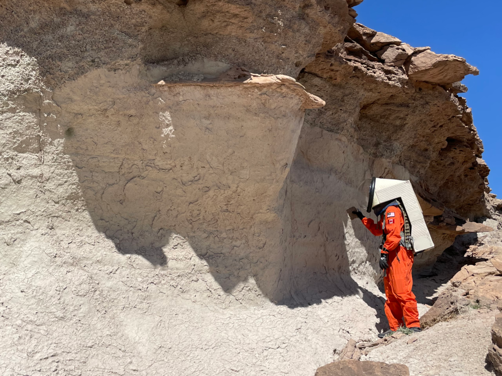
“Upon striking the projection, Jin found that much like most of the surrounding geology,” I wrote, “It was composed of a brittle, flaky outer layer that surrounded a tougher interior composed of compacted grains.” I would later discover that this observation also applied to the steep slopes we would soon attempt to scale, causing one of my toughest, most harrowing hiking experiences yet.
We proceeded on to Jotunheim. I walked up to it and confirmed that it was the right formation by GPS. I was anxious to get to work, as the heat of the Sun had already begun to get to me.
Lindsay collected the first sample on the western tip of the formation, near its base. We knelt on a bed of rich reddish-brown regolith. As she collected her sample with sterilized gloves and instruments to avoid contamination, I recorded our GPS location in my smartphone and in my waterproof notebook.
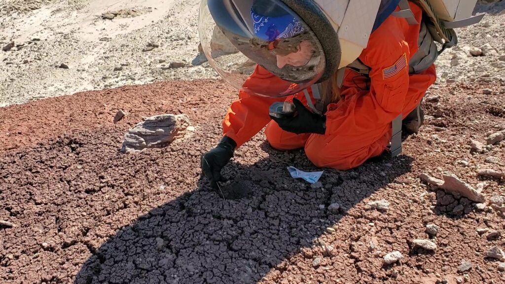
We proceeded to the second sample site. Being in the dry, hot desert air, I began to feel thirst. This was a particularly challenging site to sample, being located high on a slope of nearly forty-five degrees. As Lindsay pressed her boots into it, the ground cracked under her feet and gave way to soft, free-flowing sand underneath. She made it to the sample site eventually but struggled to stay still while she collected the sample. She nearly fell over while descending. I climbed carefully after she was finished, crawling through her collapsed footprints to get the GPS data. After a nerve-wracking descent, we walked on to the other end of the structure.
This near-miss tempered us for the third sampling site, which was also high on a steep incline of fragile ground. When descending from it, we climbed down backward for maximum control.
While collecting the fourth sample on Jotunheim’s southwestern end, I noticed two curious oval-shaped lumps in the ground near it. I joked that they were alien eggs because that’s exactly what they looked like. I pulled on one and it seemed firmly stuck in the ground, until it came clean off in my hand! It seemed to be a knob of solidified mud.

It was around this time that we realized that we had lost contact with the Hab. A ridge to our south was blocking radio communications.
“EVA team to HabComm, comm check, over.”
Silence.
“EVA team to HabComm, comm check, do you copy?”
Silence.
We decided to press on through the thirst and fatigue to collect the fifth and final sample, then begin our return to the Hab. After all the samples had been secured, we began our walk back to the rovers.
Then, I began to notice that Lindsay’s radio had problems. She would say something to me, and the ends of her sentences would be cut off. I asked her to repeat herself a few times – until I stopped hearing any transmissions from her at all. We stopped and I inspected her radio’s screen. It flashed in ominous letters ‘LO BT’; low battery. This caught us off guard because the radio had been fully charged when we had departed just over two hours ago. Suspecting a bad electrical connection, I removed and replaced the battery, but it made no difference. Thankfully, Lindsay could still receive my transmissions, although she had to yell through her helmet to talk to me.
When we got back to the rovers, I grabbed my water bottle out of the driver’s seat cup holder and attempted to drink from it with my suit on. I had to practically hang myself by my free arm from the rover’s frame, just so that I could lean far back enough to get a mouthful of water in. It was not an effective way to drink, but I at least did get to soothe my parched throat. As someone who’s cared deeply about the environment for his whole life, never had I craved more for the simple utility of the humble disposable plastic straw.
There was another problem: we could walk together without radios just fine, but driving was another matter. We would be in separate vehicles, and without two-way radio contact, one of us could easily get left behind if they experienced a problem. Since Lindsay would be able to hear me but I would not be able to hear her, I suggested that she drive ahead of me, and I would transmit verbal check-ins every few hundred metres to let her know that I was still following her. Lindsay suggested she would give a thumbs-up sign to acknowledge that she had heard me. This mixture of audio and visuals gave us a crude, but effective means of two-way communication.
I executed a three-point turn, then waited for Lindsay to drive past me.
“Lindsay, I’m right behind you, following at a distance of about five metres.”
Thumbs-up. All was well.
As we drove south back to the Hab, I continued checking in like this about once per minute while following Lindsay at a distance of five to ten metres. As we turned around the ridge that had blocked communications, I attempted to hail the Hab again.
“EVA team to HabComm, comm check, over.”
Inga’s voice crackled in the radio. “This is HabComm, we’re reading you.”
I breathed a sigh of relief. “HabComm, this is Jin,” I said. “We’re on our way back to the Hab now. Lindsay’s radio has
failed, but she is still able to receive.”
“Copy that, EVA team.”
Soon, we were within visual range of the Hab.

Just as we parked our rovers and plugged them in to charge, Lindsay’s radio failed completely. She could not receive nor transmit signals. Thankfully, we were right next to the Hab and only had to walk into the waiting airlock. I shudder to think what would have happened had her radio failed completely while we were in the field.
After the airlock had repressurized, I shuffled off my suit and made a beeline for my water bottle. I took a long, long swig. Dave had the presence of mind to turn off my suit’s ventilation and plug it in to charge for me, because that was the last thing I could think about at that moment.
It wasn’t until I had had some time to reflect on the EVA that I realized how tough it had been for the both of us, even though we were both in good physical condition and experienced in field operations (Lindsay being an MDRS veteran and me having hiked in the wilderness and scuba dived before). I realized that we had both been quick in thinking on our feet and proficient in staying cool (mentally, at least) in crises – aspects in which I had previously doubted myself. Mars was testing our limits, and we had to get smarter to reach the bar the planet had set for us.
During our postmortem in writing the EVA report, Lindsay and I recommended the following measures:
- Each EVA team member should carry a backup radio.
- If a team member brings a water supply, they should also bring a straw to allow them to drink from it while wearing a helmet.
- If available, the team should bring pictures of the target feature and its approximate geometric dimensions for easy visual identification.
- HabComm should be informed of potential radio blackout areas and be prepared for them.
The very next day, Mars would test me again. But this time, the anxiety would be reversed – I would be HabComm, and it would be my teammates in the field who were in blackout.
Footnotes
Maggiori, C., Stromberg, J., Blanco, Y., Goordial, J., Cloutis, E., Garcı, M., Parro, V., & Whyte, L. (2020). The Limits, Capabilities,
and Potential for Life Detection. Astrobiology, 20 (3), 375–394. https://doi.org/10.1089/ast.2018.1964
Be a part of this!
The Mars Society of Canada offers a professional and credible platform for all space advocates to promote Canada’s participation in Mars science and exploration. By becoming a member of our federal not-for-profit, you provide direct support for our educational, public outreach and analog research efforts. We proudly represent the voice of thousands of Canadians who believe in the profound benefit of Mars exploration, and a multi-planetary future for humanity.
Edited by Evan Plant-Weir